
Make a donation
Pasir Mas topographic map
Click on the map to display elevation.
Make a donation
About this map
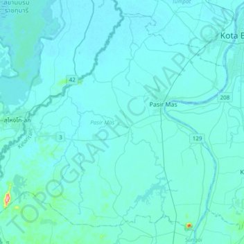
Name: Pasir Mas topographic map, elevation, terrain.
Location: Pasir Mas, Kelantan, Malaysia (5.88554 101.92133 6.15357 102.22139)
Average elevation: 12 m
Minimum elevation: -2 m
Maximum elevation: 253 m
Make a donation
Other topographic maps
Click on a map to view its topography, its elevation and its terrain.
Make a donation
Make a donation
Gunung Stong
The mountain features hill dipterocarp, upper dipterocarp and montane forests, as the elevation gradually increases. There is an abundance of flora containing beneficial and medicinal properties that can be obtained within these forests.
Average elevation: 1,105 m
Make a donation
Make a donation
Make a donation
Make a donation
Make a donation
Make a donation
Mount Chamah
Gunung Chamah lies in the north-western corner of Kelantan and is the fifth highest mountain in Peninsular Malaysia. It is one of the Peninsula's G7 (mountains above 7,000 ft/2,134m). Gunung in Malay literally means mountains with an elevation of 1,000 m and above. In Peninsular Malaysia, there are several of…
Average elevation: 1,810 m
Make a donation
Make a donation
Make a donation
Make a donation
Make a donation
Make a donation
Make a donation
Make a donation
Make a donation
Make a donation
Make a donation
Make a donation
Make a donation
Make a donation
Make a donation
Make a donation
Make a donation