
Tungurahua topographic map
Interactive map
Click on the map to display elevation.
About this map
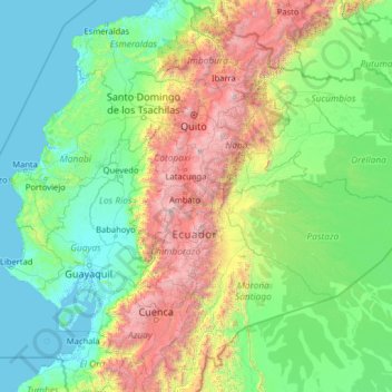
Name: Tungurahua topographic map, elevation, terrain.
Location: Tungurahua, Ecuador (-3.83659 -81.03547 1.28341 -75.91547)
Average elevation: 856 m
Minimum elevation: -2 m
Maximum elevation: 5,883 m
Other topographic maps
Click on a map to view its topography, its elevation and its terrain.
Pillaro
Ecuador > Tungurahua > Pillaro
Pillaro, Santiago de Pillaro, Tungurahua, Ecuador
Average elevation: 2,851 m
Carihuairazo
Ecuador > Tungurahua > Mocha
Carihuairazo, Mocha, Cantón Mocha, Tungurahua, Ecuador
Average elevation: 4,572 m