
Make a donation
Rio de Janeiro topographic map
Click on the map to display elevation.
Make a donation
Rio de Janeiro
Temperature also varies according to elevation, distance from the coast, and type of vegetation or land use. During the winter, cold fronts and dawn/morning sea breezes bring mild temperatures; cold fronts, the Intertropical Convergence Zone (in the form of winds from the Amazon Forest), the strongest sea-borne winds (often from an extratropical cyclone) and summer evapotranspiration bring showers or storms. Thus the monsoon-like climate has dry and mild winters and springs, and very wet and warm summers and autumns. As a result, temperatures over 40 °C (104 °F), that may happen about year-round but are much more common during the summer, often mean the actual "feels-like" temperature is over 50 °C (122 °F), when there is little wind and the relative humidity percentage is high.
Make a donation
About this map
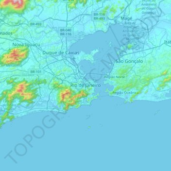
Name: Rio de Janeiro topographic map, elevation, terrain.
Average elevation: 43 m
Minimum elevation: -2 m
Maximum elevation: 1,421 m
Make a donation
Other topographic maps
Click on a map to view its topography, its elevation and its terrain.
Sugarloaf
Brazil > Rio de Janeiro > Região Metropolitana do Rio de Janeiro > Rio de Janeiro
Average elevation: 17 m
Quinta da Boa Vista
Brazil > Rio de Janeiro > Região Metropolitana do Rio de Janeiro > Rio de Janeiro
Average elevation: 19 m
Praça Heitor Bastos Tigre
Brazil > Rio de Janeiro > Região Metropolitana do Rio de Janeiro > Rio de Janeiro
Average elevation: 7 m
Make a donation
Vale das Pedrinhas
Brazil > Rio de Janeiro > Região Metropolitana do Rio de Janeiro > Guapimirim
Average elevation: 8 m
Corcovado
Brazil > Rio de Janeiro > Região Metropolitana do Rio de Janeiro > Rio de Janeiro
Average elevation: 221 m
Morro da Babilônia
Brazil > Rio de Janeiro > Região Metropolitana do Rio de Janeiro > Rio de Janeiro
Average elevation: 29 m
Make a donation
Morro da Babilônia
Brazil > Rio de Janeiro > Região Metropolitana do Rio de Janeiro > Rio de Janeiro
Average elevation: 29 m
Morro da Babilônia
Brazil > Rio de Janeiro > Região Metropolitana do Rio de Janeiro > Rio de Janeiro
Average elevation: 29 m
Make a donation
Manuel de Morais
Brazil > Rio de Janeiro > Trajano de Moraes > Visconde de Imbé
Average elevation: 362 m
Niterói
Brazil > Rio de Janeiro > Região Metropolitana do Rio de Janeiro > Niterói
Average elevation: 36 m
Make a donation
Petrópolis
Brazil > Rio de Janeiro > Região Metropolitana do Rio de Janeiro > Petrópolis
Average elevation: 683 m
Rio Aldeia
Brazil > Rio de Janeiro > Região Metropolitana do Rio de Janeiro > Itaboraí
Average elevation: 8 m
Make a donation
Praia do Leblon
Brazil > Rio de Janeiro > Região Metropolitana do Rio de Janeiro > Rio de Janeiro
Average elevation: 26 m