
Whitnash topographic map
Click on the map to display elevation.
About this map
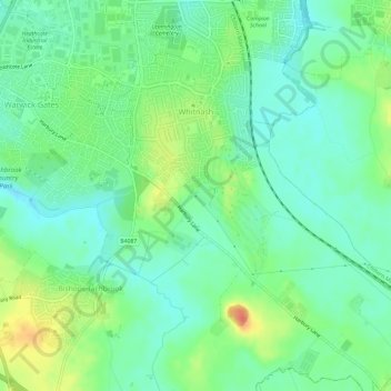
Name: Whitnash topographic map, elevation, terrain.
Location: Whitnash, Warwick, Warwickshire, England, United Kingdom (52.24006 -1.53959 52.27644 -1.49115)
Average elevation: 69 m
Minimum elevation: 53 m
Maximum elevation: 100 m
Other topographic maps
Click on a map to view its topography, its elevation and its terrain.
Rowington Green
United Kingdom > England > Warwickshire > Warwick > Rowington
Average elevation: 114 m
Hampton on the Hill
United Kingdom > England > Warwickshire > Warwick > Hampton on the Hill
Average elevation: 75 m