
Thank you for supporting this site ❤️
Make a donation
Make a donation
Ronsberg topographic map
Click on the map to display elevation.
Thank you for supporting this site ❤️
Make a donation
Make a donation
About this map
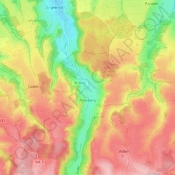
Name: Ronsberg topographic map, elevation, terrain.
Location: Ronsberg, Landkreis Ostallgäu, Bayern, 87671, Deutschland (47.87633 10.35875 47.92562 10.45081)
Average elevation: 777 m
Minimum elevation: 670 m
Maximum elevation: 861 m
Thank you for supporting this site ❤️
Make a donation
Make a donation
Other topographic maps
Click on a map to view its topography, its elevation and its terrain.
Hopfensee
Deutschland > Bayern > Landkreis Ostallgäu > Füssen > Hopfen am See
Average elevation: 799 m