
Ulm topographic map
Click on the map to display elevation.
Ulm
Ulm lies at the point where the rivers Blau and Iller join the Danube, at an altitude of 479 m (1,571.52 ft) above sea level. Most parts of the city, including the old town, are situated on the northern bank of the Danube; only the districts of Wiblingen, Gögglingen, Donaustetten and Unterweiler lie on the southern bank. Across from the old town, on the other side of the river, lies the twin city of Neu-Ulm in the state of Bavaria, smaller than Ulm and, until 1810, a part of it (population c. 50,000).
About this map
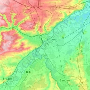
Name: Ulm topographic map, elevation, terrain.
Location: Ulm, Baden-Württemberg, Germany (48.30666 9.84205 48.46852 10.04283)
Average elevation: 518 m
Minimum elevation: 448 m
Maximum elevation: 646 m
Other topographic maps
Click on a map to view its topography, its elevation and its terrain.