
Brecon Beacons National Park topographic map
Interactive map
Click on the map to display elevation.
Brecon Beacons National Park
Brecon Beacons National Park, officially named Bannau Brycheiniog National Park (Welsh pronunciation), is a national park in Wales. It is named after the Brecon Beacons (Welsh: Bannau Brycheiniog), the mountain range at its centre. The national park includes the highest mountain in South Wales, Pen y Fan, which has an elevation of 886 metres (2,907 ft).
About this map
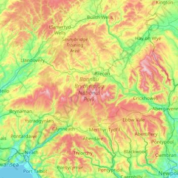
Name: Brecon Beacons National Park topographic map, elevation, terrain.
Location: Brecon Beacons National Park, Powys, Wales, United Kingdom (51.70208 -3.98959 52.07830 -2.95207)
Average elevation: 270 m
Minimum elevation: 0 m
Maximum elevation: 859 m
Other topographic maps
Click on a map to view its topography, its elevation and its terrain.
Grwyne Fawr Reservoir
United Kingdom > Wales > Powys
By the end of the 19th-century there were serious water shortages in the western parts of the historic county of Monmouthshire. The area had seen a massive population increase as a result of the steel and coal industries but the supply of water to the area was complicated due to its high altitude. A site for a…
Average elevation: 619 m
River Severn
United Kingdom > Wales > Powys > Welshpool
The River Severn (Welsh: Afon Hafren, pronounced [ˈavɔn ˈhavrɛn]), at 220 miles (354 km) long, is the longest river in Great Britain. It is also the river with the most voluminous flow of water by far in all of England and Wales, with an average flow rate of 107 m3/s (3,800 cu ft/s) at Apperley,…
Average elevation: 92 m
Craig Cerrig Gleisiad a Fan Frynych National Nature Reserve
United Kingdom > Wales > Powys
Average elevation: 473 m