
Middleburg topographic map
Click on the map to display elevation.
Middleburg
According to the United States Census Bureau, the town has a total area of 0.6 square mile (1.5 km2), all land. The elevation is 486 feet.
About this map
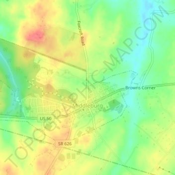
Name: Middleburg topographic map, elevation, terrain.
Location: Middleburg, Loudoun County, Virginia, United States (38.96298 -77.75946 38.98059 -77.72547)
Average elevation: 143 m
Minimum elevation: 113 m
Maximum elevation: 173 m
Other topographic maps
Click on a map to view its topography, its elevation and its terrain.
Loudoun Valley Estates
United States > Virginia > Loudoun County
The land around Loudoun Valley Estates is gently rolling. The average elevation is 289 feet (88 m). The population density is about 500 people per square kilometer.
Average elevation: 91 m
Paris Mountain
United States > Virginia > Loudoun County
Paris Mountain is a peak of Blue Ridge Mountain on the border of Loudoun County and Clarke County in Virginia. The 1,926 feet (587 m) peak, which is located just north of Ashby's Gap and the town of Paris, for which it is named, represents the highest elevation in both counties. The peak is accessible by Blue…
Average elevation: 452 m