
Jersey topographic map
Interactive map
Click on the map to display elevation.
Jersey
Jersey is an island measuring 46.2 square miles (119.6 km2) (or 66,436 vergées), including reclaimed land and intertidal zone. It lies in the English Channel, about 12 nautical miles (22 km; 14 mi) from the Cotentin Peninsula in Normandy, France, and about 87 nautical miles (161 km; 100 mi) south of Great Britain. It is the largest and southernmost of the Channel Islands and part of the British Isles, with a maximum land elevation of 143 m (469 ft) above sea level.
About this map
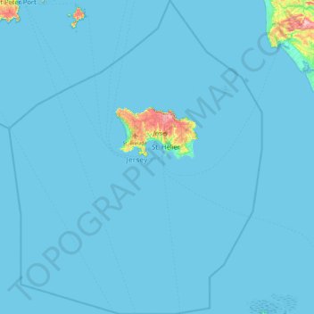
Name: Jersey topographic map, elevation, terrain.
Location: Jersey (48.87120 -2.56055 49.45961 -1.83470)
Average elevation: 4 m
Minimum elevation: 0 m
Maximum elevation: 142 m