
Parque Nacional El Tamá topographic map
Interactive map
Click on the map to display elevation.
About this map
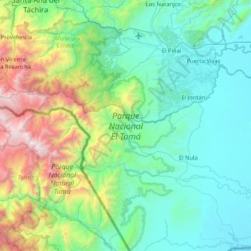
Name: Parque Nacional El Tamá topographic map, elevation, terrain.
Location: Parque Nacional El Tamá, Municipio Páez, Apure, Venezuela (7.05689 -72.47055 7.64890 -71.94906)
Average elevation: 866 m
Minimum elevation: 174 m
Maximum elevation: 3,626 m
Other topographic maps
Click on a map to view its topography, its elevation and its terrain.