Polavaram topographic map
Interactive map
Click on the map to display elevation.
About this map
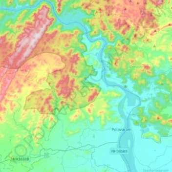
Name: Polavaram topographic map, elevation, terrain.
Location: Polavaram, Eluru District, Andhra Pradesh, India (17.16925 81.42367 17.48055 81.67969)
Average elevation: 219 m
Minimum elevation: 3 m
Maximum elevation: 759 m
Other topographic maps
Click on a map to view its topography, its elevation and its terrain.
Pothireddypadu
India > Andhra Pradesh > Jupadu Bungalow
Pothireddypadu, Jupadu Bungalow, Nandyal District, Andhra Pradesh, India
Average elevation: 272 m
Srisailam
Srisailam, Nandyal District, Andhra Pradesh, India
Average elevation: 435 m
Kuduru
India > Andhra Pradesh > Kuduru
Kuduru, Krishna, Pedana, Andhra Pradesh, 521366, India
Average elevation: 5 m
Eluru
India > Andhra Pradesh > Eluru
Eluru, West Godavari, Andhra Pradesh, 534001, India
Average elevation: 22 m
Manikonda
India > Andhra Pradesh > Manikonda
Manikonda, Krishna, Andhra Pradesh, India
Average elevation: 12 m
Kotta Pandillapalle
India > Andhra Pradesh > Kotta Pandillapalle
Kotta Pandillapalle, Prakasam, Andhra Pradesh, 523187, India
Average elevation: 5 m