
Thank you for supporting this site ❤️
Make a donation
Make a donation
Biruwa topographic map
Click on the map to display elevation.
Thank you for supporting this site ❤️
Make a donation
Make a donation
About this map
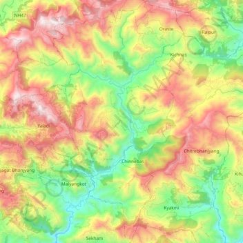
Name: Biruwa topographic map, elevation, terrain.
Location: Biruwa, Syangja, Gandaki Pradesh, Nepal (27.91339 83.84759 28.07582 83.94675)
Average elevation: 973 m
Minimum elevation: 402 m
Maximum elevation: 1,690 m
Thank you for supporting this site ❤️
Make a donation
Make a donation
Other topographic maps
Click on a map to view its topography, its elevation and its terrain.