
Make a donation
Upana Caves topographic map
Click on the map to display elevation.
Make a donation
About this map
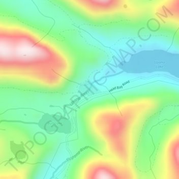
Name: Upana Caves topographic map, elevation, terrain.
Average elevation: 684 m
Minimum elevation: 494 m
Maximum elevation: 1,012 m
Make a donation
Other topographic maps
Click on a map to view its topography, its elevation and its terrain.
Whiteley Island
Canada > British Columbia > Strathcona Regional District > Area A (Kyuquot/Nootka/Sayward)
Average elevation: 16 m
Victor Island
Canada > British Columbia > Strathcona Regional District > Area A (Kyuquot/Nootka/Sayward)
Average elevation: 26 m
Alder Grove Recreation Site
Canada > British Columbia > Strathcona Regional District > Area A (Kyuquot/Nootka/Sayward)
Average elevation: 232 m
Ensanada Islet
Canada > British Columbia > Strathcona Regional District > Area A (Kyuquot/Nootka/Sayward)
Average elevation: 2 m
Make a donation
Solander Island
Canada > British Columbia > Strathcona Regional District > Area A (Kyuquot/Nootka/Sayward)
Average elevation: 0 m
Muchalat Lake
Canada > British Columbia > Strathcona Regional District > Area A (Kyuquot/Nootka/Sayward)
Average elevation: 535 m