
Thank you for supporting this site ❤️
Make a donation
Make a donation
Dhulikhel topographic map
Click on the map to display elevation.
Thank you for supporting this site ❤️
Make a donation
Make a donation
About this map
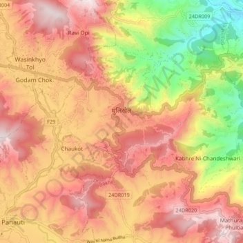
Name: Dhulikhel topographic map, elevation, terrain.
Location: Dhulikhel, Kavrepalanchok, Bagmati Pradesh, Nepal (27.59224 85.53050 27.63848 85.61317)
Average elevation: 1,348 m
Minimum elevation: 855 m
Maximum elevation: 1,816 m
Thank you for supporting this site ❤️
Make a donation
Make a donation