
Make a donation
Ugenhof topographic map
Click on the map to display elevation.
Make a donation
About this map
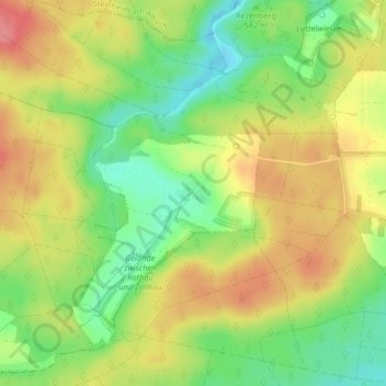
Name: Ugenhof topographic map, elevation, terrain.
Average elevation: 580 m
Minimum elevation: 539 m
Maximum elevation: 620 m
Make a donation
Other topographic maps
Click on a map to view its topography, its elevation and its terrain.
Flurstück Anhausen
Deutschland > Baden-Württemberg > Landkreis Heidenheim > Herbrechtingen
Average elevation: 560 m
Lixenfeld
Deutschland > Baden-Württemberg > Landkreis Heidenheim > Herbrechtingen
Average elevation: 580 m
Bolheim
Deutschland > Baden-Württemberg > Landkreis Heidenheim > Herbrechtingen
Average elevation: 548 m
89542
Deutschland > Baden-Württemberg > Landkreis Heidenheim > Herbrechtingen > Bolheim
Average elevation: 534 m
Make a donation
Eselsburger Tal
Deutschland > Baden-Württemberg > Landkreis Heidenheim > Herbrechtingen > Anhausen
Average elevation: 511 m
Hausen ob Lontal
Deutschland > Baden-Württemberg > Landkreis Heidenheim > Herbrechtingen
Average elevation: 532 m