
Thank you for supporting this site ❤️
Make a donation
Make a donation
Matahiwi topographic map
Click on the map to display elevation.
Thank you for supporting this site ❤️
Make a donation
Make a donation
About this map
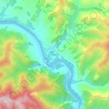
Name: Matahiwi topographic map, elevation, terrain.
Average elevation: 224 m
Minimum elevation: 13 m
Maximum elevation: 602 m
Thank you for supporting this site ❤️
Make a donation
Make a donation
Other topographic maps
Click on a map to view its topography, its elevation and its terrain.
Lake Wiritoa
New Zealand > Manawatu-Whanganui > Whanganui District > Whanganui > Pauri Village
Average elevation: 50 m
Kaitoke Lake
New Zealand > Manawatu-Whanganui > Whanganui District > Whanganui
Average elevation: 41 m
Lake Pauri
New Zealand > Manawatu-Whanganui > Whanganui District > Whanganui > Pauri Village
Average elevation: 57 m
Thank you for supporting this site ❤️
Make a donation
Make a donation