
Thank you for supporting this site ❤️
Make a donation
Make a donation
Vicht topographic map
Click on the map to display elevation.
Thank you for supporting this site ❤️
Make a donation
Make a donation
Vicht
Vicht liegt in der Nordeifel im Nordteil des deutsch-belgischen Naturpark Hohes Venn-Eifel. Es erstreckt sich in nordsüdlicher Ausdehnung entlang des Vichtbachs (Vicht), der von Zweifall kommend und etwa zwei Drittel des Ortes durchquerend etwa nach Norden in Richtung Stolberg fließt. Das Dorf liegt auf etwa 263 m ü. NHN Höhe.
Thank you for supporting this site ❤️
Make a donation
Make a donation
About this map
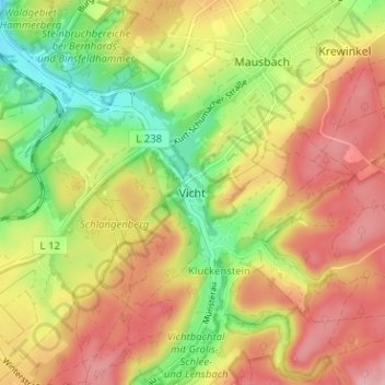
Name: Vicht topographic map, elevation, terrain.
Average elevation: 273 m
Minimum elevation: 198 m
Maximum elevation: 339 m
Thank you for supporting this site ❤️
Make a donation
Make a donation
Other topographic maps
Click on a map to view its topography, its elevation and its terrain.
Vichtbachtal mit Grölis-, Schlee- und Lensbach
Deutschland > Nordrhein-Westfalen > Städteregion Aachen > Stolberg > Vicht
Average elevation: 376 m