
Thank you for supporting this site ❤️
Make a donation
Make a donation
Rambali topographic map
Click on the map to display elevation.
Thank you for supporting this site ❤️
Make a donation
Make a donation
About this map
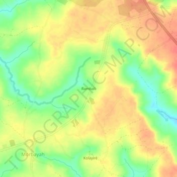
Name: Rambali topographic map, elevation, terrain.
Location: Rambali, Kindia Region, Guinea (9.28090 -13.08012 9.32090 -13.04012)
Average elevation: 38 m
Minimum elevation: 8 m
Maximum elevation: 61 m
Thank you for supporting this site ❤️
Make a donation
Make a donation
Other topographic maps
Click on a map to view its topography, its elevation and its terrain.