
Baja California topographic map
Interactive map
Click on the map to display elevation.
Baja California
In the main terrestrial wildlife refuges on the peninsula of Baja California, Constitution 1857 National Park and Sierra de San Pedro Mártir National Park contain several coniferous species; the most abundant are: pinus jeffreyi, pinus ponderosa, pinus cembroide, pinus quadrifolia, pinus monophylla, juniperus, arctostaphylos drupacea, artemisa ludoviciana, and adenostoma esparcifolium. The flora share many species with the Laguna Mountains and San Jacinto Mountains in southwest California. The lower elevations of the Sierra Juárez are characterized by chaparral and desert shrub.
About this map
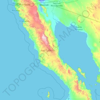
Name: Baja California topographic map, elevation, terrain.
Location: Baja California, Mexico (27.99999 -118.36487 32.71866 -112.76493)
Average elevation: 179 m
Minimum elevation: -12 m
Maximum elevation: 2,850 m