
Thank you for supporting this site ❤️
Make a donation
Make a donation
Kirchhellen topographic map
Click on the map to display elevation.
Thank you for supporting this site ❤️
Make a donation
Make a donation
Kirchhellen
Der Ortsname leitet sich von Kirche auf dem Hügel (Helle) ab und bezieht sich auf den historischen, auf einer Anhöhe im Dorf gelegenen Platz der alten Dorfkirche, die im Jahr 1917 durch einen Brand zerstört wurde. Das heutige Dorfbild wird geprägt von der 1925 eingeweihten, an der Hauptstraße gelegenen St.-Johannes-Kirche.
Thank you for supporting this site ❤️
Make a donation
Make a donation
About this map
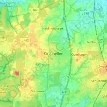
Name: Kirchhellen topographic map, elevation, terrain.
Location: Kirchhellen, Bottrop, Nordrhein-Westfalen, 46244, Deutschland (51.56375 6.88005 51.64375 6.96005)
Average elevation: 56 m
Minimum elevation: 35 m
Maximum elevation: 89 m
Thank you for supporting this site ❤️
Make a donation
Make a donation
Other topographic maps
Click on a map to view its topography, its elevation and its terrain.
Thank you for supporting this site ❤️
Make a donation
Make a donation
Thank you for supporting this site ❤️
Make a donation
Make a donation