
Thank you for supporting this site ❤️
Make a donation
Make a donation
Cumandá topographic map
Click on the map to display elevation.
Thank you for supporting this site ❤️
Make a donation
Make a donation
About this map
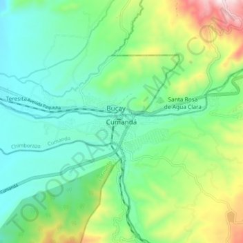
Name: Cumandá topographic map, elevation, terrain.
Location: Cumandá, Cumanda, Chimborazo, 091605, Ecuador (-2.24498 -79.17584 -2.16498 -79.09584)
Average elevation: 413 m
Minimum elevation: 208 m
Maximum elevation: 930 m
Thank you for supporting this site ❤️
Make a donation
Make a donation
Other topographic maps
Click on a map to view its topography, its elevation and its terrain.