
Thank you for supporting this site ❤️
Make a donation
Make a donation
Unterbränd topographic map
Click on the map to display elevation.
Thank you for supporting this site ❤️
Make a donation
Make a donation
About this map
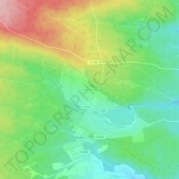
Name: Unterbränd topographic map, elevation, terrain.
Average elevation: 835 m
Minimum elevation: 760 m
Maximum elevation: 959 m
Thank you for supporting this site ❤️
Make a donation
Make a donation
Other topographic maps
Click on a map to view its topography, its elevation and its terrain.
Unterbränd
Deutschland > Baden-Württemberg > Schwarzwald-Baar-Kreis > Bräunlingen
Average elevation: 831 m
78199
Deutschland > Baden-Württemberg > Schwarzwald-Baar-Kreis > Bräunlingen > Waldhausen
Average elevation: 777 m
Döggingen
Deutschland > Baden-Württemberg > Schwarzwald-Baar-Kreis > Bräunlingen
Average elevation: 755 m