
Thank you for supporting this site ❤️
Make a donation
Make a donation
La Bruyère topographic map
Click on the map to display elevation.
Thank you for supporting this site ❤️
Make a donation
Make a donation
About this map
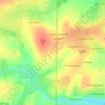
Name: La Bruyère topographic map, elevation, terrain.
Average elevation: 61 m
Minimum elevation: 30 m
Maximum elevation: 83 m
Thank you for supporting this site ❤️
Make a donation
Make a donation
Other topographic maps
Click on a map to view its topography, its elevation and its terrain.
Château-Gontier
France > Pays de la Loire > Mayenne > Château-Gontier-sur-Mayenne
Average elevation: 61 m
53200
France > Pays de la Loire > Mayenne > Château-Gontier-sur-Mayenne > Château-Gontier
Average elevation: 73 m
Plan d'eau de la Roche
France > Pays de la Loire > Mayenne > Château-Gontier-sur-Mayenne
Average elevation: 54 m
Thank you for supporting this site ❤️
Make a donation
Make a donation
Jardin du Bout du Monde
France > Pays de la Loire > Mayenne > Château-Gontier-sur-Mayenne > Château-Gontier
Average elevation: 51 m