
Thank you for supporting this site ❤️
Make a donation
Make a donation
Village du Pradet topographic map
Click on the map to display elevation.
Thank you for supporting this site ❤️
Make a donation
Make a donation
About this map
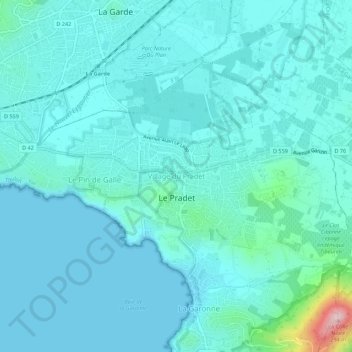
Name: Village du Pradet topographic map, elevation, terrain.
Average elevation: 34 m
Minimum elevation: -1 m
Maximum elevation: 285 m
Thank you for supporting this site ❤️
Make a donation
Make a donation
Other topographic maps
Click on a map to view its topography, its elevation and its terrain.
Plage du Monaco
France > Provence-Alpes-Côte d'Azur > Var > Le Pradet > Village du Pradet
Average elevation: 19 m