
South Shore topographic map
Interactive map
Click on the map to display elevation.
About this map
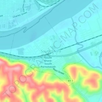
Name: South Shore topographic map, elevation, terrain.
Location: South Shore, Greenup County, Kentucky, United States (38.71295 -82.97670 38.73153 -82.95136)
Average elevation: 190 m
Minimum elevation: 153 m
Maximum elevation: 294 m
Other topographic maps
Click on a map to view its topography, its elevation and its terrain.
Load
United States > Kentucky > Greenup County
Load, Greenup County, Kentucky, United States
Average elevation: 222 m
Frost
United States > Kentucky > Greenup County
Frost, Greenup County, Kentucky, 41175, United States
Average elevation: 180 m
Flatwoods
United States > Kentucky > Greenup County
Flatwoods, Greenup County, Kentucky, United States
Average elevation: 194 m
Raceland
United States > Kentucky > Greenup County
Raceland, Greenup County, Kentucky, United States
Average elevation: 185 m
Oldtown
United States > Kentucky > Greenup County
Oldtown, Greenup County, Kentucky, 41122, United States
Average elevation: 205 m
Hunnewell
United States > Kentucky > Greenup County
Hunnewell, Greenup County, Kentucky, 41122, United States
Average elevation: 221 m
Sunshine
United States > Kentucky > Greenup County
Sunshine, Greenup County, Kentucky, 41175, United States
Average elevation: 193 m
Lloyd
United States > Kentucky > Greenup County
Lloyd, Greenup County, Kentucky, 45629, United States
Average elevation: 188 m
Wurtland
United States > Kentucky > Greenup County
Wurtland, Greenup County, Kentucky, United States
Average elevation: 181 m
Worthington
United States > Kentucky > Greenup County
Worthington, Greenup County, Kentucky, 41183, United States
Average elevation: 182 m
Russell
United States > Kentucky > Greenup County
Russell, Greenup County, Kentucky, United States
Average elevation: 192 m
Argillite
United States > Kentucky > Greenup County
Argillite, Greenup County, Kentucky, 41121, United States
Average elevation: 198 m
Bellefonte
United States > Kentucky > Greenup County
Bellefonte, Greenup County, Kentucky, United States
Average elevation: 188 m
Greenup
United States > Kentucky > Greenup County
Greenup, Greenup County, Kentucky, United States
Average elevation: 176 m