
Thank you for supporting this site ❤️
Make a donation
Make a donation
Truison topographic map
Click on the map to display elevation.
Thank you for supporting this site ❤️
Make a donation
Make a donation
About this map
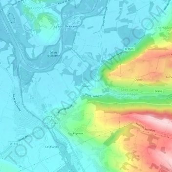
Name: Truison topographic map, elevation, terrain.
Average elevation: 264 m
Minimum elevation: 205 m
Maximum elevation: 465 m
Thank you for supporting this site ❤️
Make a donation
Make a donation
Other topographic maps
Click on a map to view its topography, its elevation and its terrain.
Saint-Maurice-de-Rotherens
France > Auvergne-Rhône-Alpes > Savoie > Saint-Genix-les-Villages
Average elevation: 570 m
73240
France > Auvergne-Rhône-Alpes > Savoie > Saint-Genix-les-Villages > Le Cerisier
Average elevation: 374 m
Saint-Genix-sur-Guiers
France > Auvergne-Rhône-Alpes > Savoie > Saint-Genix-les-Villages
Average elevation: 320 m
Thank you for supporting this site ❤️
Make a donation
Make a donation
Saint-Genix-sur-Guiers
France > Auvergne-Rhône-Alpes > Savoie > Saint-Genix-les-Villages
Average elevation: 320 m