
Make a donation
Mineral del Monte topographic map
Click on the map to display elevation.
Make a donation
Mineral del Monte
It is located at an altitude of 2,700 metres (8,900 ft) on a mountain pass, it is the highest town in Hidalgo. As of 2020, the municipality had a total population of 14,324 — with Mauricio Rodriguez Téllez as head of the municipal council.
Make a donation
About this map
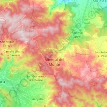
Name: Mineral del Monte topographic map, elevation, terrain.
Location: Mineral del Monte, Hidalgo, Mexico (20.08815 -98.70279 20.20723 -98.60498)
Average elevation: 2,686 m
Minimum elevation: 2,257 m
Maximum elevation: 3,048 m
Make a donation
Other topographic maps
Click on a map to view its topography, its elevation and its terrain.
Pachuca
Mexico > Hidalgo > Pachuca de Soto
Pachuca has a semi-arid climate (Köppen climate classification BSk). The climate is cool with high rainfall and occasional hail during the summer months and dry conditions during the winter. The coldest month is January, with an average high of 20 °C (68 °F) and an average low of 3 °C (37 °F). Winter…
Average elevation: 2,459 m
Make a donation
Make a donation
Santiago Tulantepec
Mexico > Hidalgo > Santiago Tulantepec de Lugo Guerrero
Average elevation: 2,260 m
Pachuca
Mexico > Hidalgo > Pachuca de Soto
Pachuca has a semi-arid climate (Köppen climate classification BSk). The climate is cool with high rainfall and occasional hail during the summer months and dry conditions during the winter. The coldest month is January, with an average high of 20 °C (68 °F) and an average low of 3 °C (37 °F). Winter…
Average elevation: 2,459 m
Make a donation
Make a donation
Col. Loma Bonita
Mexico > Hidalgo > Atotonilco de Tula > Atotonilco de Tula > Col. Loma Bonita
Average elevation: 2,164 m
Make a donation