
Thank you for supporting this site ❤️
Make a donation
Make a donation
06636 topographic map
Click on the map to display elevation.
Thank you for supporting this site ❤️
Make a donation
Make a donation
About this map
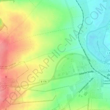
Name: 06636 topographic map, elevation, terrain.
Average elevation: 146 m
Minimum elevation: 105 m
Maximum elevation: 198 m
Thank you for supporting this site ❤️
Make a donation
Make a donation
Other topographic maps
Click on a map to view its topography, its elevation and its terrain.
Dorndorf
Deutschland > Sachsen-Anhalt > Burgenlandkreis > Laucha an der Unstrut
Dorndorf ist vermutlich eine fränkische Neugründung aus dem 8. Jahrhundert. Das Dorf wurde 1271 erstmals urkundlich erwähnt. Der erste Ort Dorndorf soll sich auf der Anhöhe, oberhalb der Straße Dorndorf-Gleina befunden haben. Die Lehnshoheit im Ort und an den Gütern darinnen, besaßen die Markgrafen von…
Average elevation: 150 m