Geolocate

Westfield topographic map

Click on the map to display elevation.

About this map

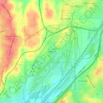
Name: Westfield topographic map, elevation, terrain.

Location: Westfield, Jefferson County, Alabama, 35064, United States (33.46455 -86.96055 33.50455 -86.92055)

Average elevation: 187 m

Minimum elevation: 153 m

Maximum elevation: 226 m

Other topographic maps

Click on a map to view its topography, its elevation and its terrain.

Trafford

United States > Alabama > Jefferson County

Average elevation: 146 m

Brighton

United States > Alabama > Jefferson County

Average elevation: 160 m

McCalla

United States > Alabama > Jefferson County > McCalla

Average elevation: 167 m

Hueytown

United States > Alabama > Jefferson County

Average elevation: 164 m

Cardiff

United States > Alabama > Jefferson County

Average elevation: 144 m

Midfield

United States > Alabama > Jefferson County

Average elevation: 172 m

Lipscomb

United States > Alabama > Jefferson County

Average elevation: 169 m

Bessemer

United States > Alabama > Jefferson County

Average elevation: 174 m

Bankhead Lake

United States > Alabama > Jefferson County

Average elevation: 122 m

Trussville

United States > Alabama > Jefferson County

Average elevation: 265 m

Gardendale

United States > Alabama > Jefferson County

Average elevation: 180 m

Fultondale

United States > Alabama > Jefferson County > Fultondale

Due to difficult topography, for many years Fultondale was limited in its ability to grow. However, as technology improved, the ability to convert what had been difficult to unusable land for retail and commercial purposes improved. Besides the retail development of Colonial Promenade, other retail development…

Average elevation: 190 m

Adamsville

United States > Alabama > Jefferson County

Average elevation: 162 m

Center Point

United States > Alabama > Jefferson County

Average elevation: 245 m

Hueytown

United States > Alabama > Jefferson County

Average elevation: 168 m

Warrior

United States > Alabama > Jefferson County > Warrior

Warrior is in the Central time zone. The elevation at the center of town is 564 feet (172 m), though it ranges from over 620 feet (190 m) north of the center to less than 300 feet (91 m) along the Locust Fork of the Black Warrior River, which forms the southern boundary of the city.

Average elevation: 149 m

Tarrant

United States > Alabama > Jefferson County

Average elevation: 190 m

Leeds

United States > Alabama > Jefferson County

Average elevation: 200 m

Rock Creek

United States > Alabama > Jefferson County

Average elevation: 148 m

Fairfield

United States > Alabama > Jefferson County

Average elevation: 176 m

Morris

United States > Alabama > Jefferson County

Average elevation: 140 m

Mulga

United States > Alabama > Jefferson County

Average elevation: 180 m

North Johns

United States > Alabama > Jefferson County

Average elevation: 151 m

Concord

United States > Alabama > Jefferson County > Concord

Average elevation: 168 m

Minor

United States > Alabama > Jefferson County > McDonald Chapel > Minor

Average elevation: 180 m

Kimberly

United States > Alabama > Jefferson County

Average elevation: 140 m

Graysville

United States > Alabama > Jefferson County

Average elevation: 138 m

Fairfield

United States > Alabama > Jefferson County

Average elevation: 176 m

Morris

United States > Alabama > Jefferson County > Morris

Average elevation: 140 m

Helena

United States > Alabama > Jefferson County

Average elevation: 183 m