
Make a donation
Okonoko topographic map
Click on the map to display elevation.
Make a donation
Okonoko
Okonoko is positioned at an elevation of 173 metres (568 ft). The unincorporated community of Little Cacapon is located approximately 1.7 miles (2.7 km) east of Okonoko, the unincorporated community of Levels is located approximately 3.1 miles (5.0 km) to its southwest, and the town of Paw Paw is located approximately 3.5 miles (5.6 km) to its east. Okonoko is accessible from Levels, Little Cacapon, and Paw Paw via Okonoko Road. The Chesapeake and Ohio Canal and the Chesapeake and Ohio Canal National Historical Park are located directly across the Potomac River from Okonoko, in Maryland.
Make a donation
About this map
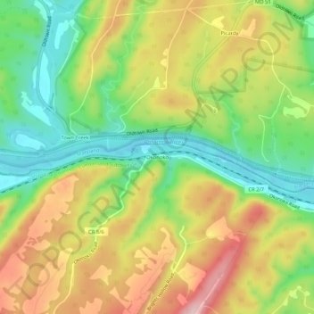
Name: Okonoko topographic map, elevation, terrain.
Average elevation: 251 m
Minimum elevation: 149 m
Maximum elevation: 370 m
Make a donation
Other topographic maps
Click on a map to view its topography, its elevation and its terrain.