
Thank you for supporting this site ❤️
Make a donation
Make a donation
Midway topographic map
Click on the map to display elevation.
Thank you for supporting this site ❤️
Make a donation
Make a donation
About this map
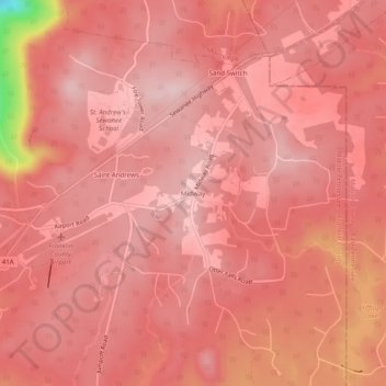
Name: Midway topographic map, elevation, terrain.
Average elevation: 579 m
Minimum elevation: 375 m
Maximum elevation: 621 m
Thank you for supporting this site ❤️
Make a donation
Make a donation
Other topographic maps
Click on a map to view its topography, its elevation and its terrain.
City of Decherd Babe Ruth Ball Park
United States > Tennessee > Franklin County > Decherd
Average elevation: 300 m