Bridgewater topographic map
Interactive map
Click on the map to display elevation.
About this map
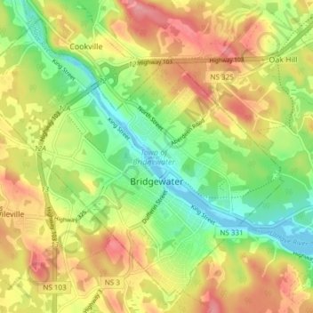
Name: Bridgewater topographic map, elevation, terrain.
Location: Bridgewater, Lunenburg County, Nova Scotia, Canada (44.35760 -64.56427 44.40550 -64.48875)
Average elevation: 56 m
Minimum elevation: -2 m
Maximum elevation: 118 m
Bridgewater spans the width of the LaHave River Valley and is dominated by hills that lead down to the river. Elevations range from 5 metres above sea level at the river, to nearly 110 m at the southwestern border. Like much of Southern Nova Scotia, the surrounding area is characterized by rolling drumlins formed during the last glacial period, some of which reach 150 metres above sea level. The LaHave River is traversed by two bridges in the centre of the town, as well as a 103 highway overpass and foot bridge towards the northern limits.
Other topographic maps
Click on a map to view its topography, its elevation and its terrain.
Oak Island
Canada > Nova Scotia > Lunenburg County > Western Shore
Oak Island, Western Shore, Chester District Municipality, Lunenburg County, Nova Scotia, B0J 3M0, Canada
Average elevation: 74 m
Chester Basin
Canada > Nova Scotia > Lunenburg County > Chester Islands
Chester Basin, Chester Islands, Chester District Municipality, Lunenburg County, Nova Scotia, Canada
Average elevation: 10 m
Oakland
Canada > Nova Scotia > Lunenburg County
Oakland, Municipality of the District of Lunenburg, Lunenburg County, Nova Scotia, B0J 2E0, Canada
Average elevation: 23 m
Stanley Section
Canada > Nova Scotia > Lunenburg County
Stanley Section, Municipality of the District of Lunenburg, Lunenburg County, Nova Scotia, Canada
Average elevation: 98 m
Lower Rose Bay
Canada > Nova Scotia > Lunenburg County
Lower Rose Bay, Municipality of the District of Lunenburg, Lunenburg County, Nova Scotia, B0J 2X0, Canada
Average elevation: 23 m
Oak Island
Canada > Nova Scotia > Lunenburg County > Western Shore
Oak Island, Western Shore, Chester District Municipality, Lunenburg County, Nova Scotia, B0J 3M0, Canada
Average elevation: 2 m
Crousetown
Canada > Nova Scotia > Lunenburg County
Crousetown, Municipality of the District of Lunenburg, Lunenburg County, Nova Scotia, Canada
Average elevation: 49 m
New Russell
Canada > Nova Scotia > Lunenburg County
New Russell, Chester District Municipality, Lunenburg County, Nova Scotia, B0J 2M0, Canada
Average elevation: 205 m
Chester
Canada > Nova Scotia > Lunenburg County
Chester, Chester District Municipality, Lunenburg County, Nova Scotia, B0J 1J0, Canada
Average elevation: 16 m
Upper Kingsburg
Canada > Nova Scotia > Lunenburg County
Upper Kingsburg, Municipality of the District of Lunenburg, Lunenburg County, Nova Scotia, B0J 2X0, Canada
Average elevation: 9 m
Blue Rocks
Canada > Nova Scotia > Lunenburg County
Blue Rocks, Municipality of the District of Lunenburg, Lunenburg County, Nova Scotia, B0J 2C0, Canada
Average elevation: 4 m
Mason Island
Canada > Nova Scotia > Lunenburg County > Indian Point
Mason Island, Indian Point, Municipality of the District of Lunenburg, Lunenburg County, Nova Scotia, B0J 2E0, Canada
Average elevation: 0 m
Bayport
Canada > Nova Scotia > Lunenburg County
Bayport, Municipality of the District of Lunenburg, Lunenburg County, Nova Scotia, B0J 2X0, Canada
Average elevation: 12 m
Maitland
Canada > Nova Scotia > Lunenburg County
Maitland, Municipality of the District of Lunenburg, Lunenburg County, Nova Scotia, Canada
Average elevation: 76 m
Mount Pleasant
Canada > Nova Scotia > Lunenburg County
Mount Pleasant, Municipality of the District of Lunenburg, Lunenburg County, Nova Scotia, B0R 1G0, Canada
Average elevation: 61 m
Upper LaHave
Canada > Nova Scotia > Lunenburg County
Upper LaHave, Municipality of the District of Lunenburg, Lunenburg County, Nova Scotia, Canada
Average elevation: 30 m
Middle New Cornwall
Canada > Nova Scotia > Lunenburg County
Middle New Cornwall, Municipality of the District of Lunenburg, Lunenburg County, Nova Scotia, B0R 1A0, Canada
Average elevation: 90 m
Dayspring
Canada > Nova Scotia > Lunenburg County
Dayspring, Municipality of the District of Lunenburg, Lunenburg County, Nova Scotia, Canada
Average elevation: 42 m
Seffernville
Canada > Nova Scotia > Lunenburg County
Seffernville, Chester District Municipality, Lunenburg County, Nova Scotia, B0J 2M0, Canada
Average elevation: 121 m
Upper New Cornwall
Canada > Nova Scotia > Lunenburg County
Upper New Cornwall, Municipality of the District of Lunenburg, Lunenburg County, Nova Scotia, B0R 1A0, Canada
Average elevation: 101 m
Newcombville
Canada > Nova Scotia > Lunenburg County
Newcombville, Municipality of the District of Lunenburg, Lunenburg County, Nova Scotia, B4V 7V8, Canada
Average elevation: 102 m
Hebbville
Canada > Nova Scotia > Lunenburg County
Hebbville, Municipality of the District of Lunenburg, Lunenburg County, Nova Scotia, Canada
Average elevation: 71 m
Canoran Lake
Canada > Nova Scotia > Lunenburg County > Newburne
Canoran Lake, Newburne, Municipality of the District of Lunenburg, Lunenburg County, Nova Scotia, B0R 1A0, Canada
Average elevation: 135 m
Deep Cove
Canada > Nova Scotia > Lunenburg County > Deep Cove
Deep Cove, Chester District Municipality, Lunenburg County, Nova Scotia, B0J 1T0, Canada
Average elevation: 30 m
Town of Mahone Bay
Canada > Nova Scotia > Lunenburg County
Town of Mahone Bay, Lunenburg County, Nova Scotia, Canada
Average elevation: 32 m
Big Tancook Island
Canada > Nova Scotia > Lunenburg County
Big Tancook Island, Municipality of the District of Lunenburg, Lunenburg County, Nova Scotia, B0J 1J0, Canada
Average elevation: 1 m
Moshers Island
Canada > Nova Scotia > Lunenburg County
Moshers Island, Municipality of the District of Lunenburg, Lunenburg County, Nova Scotia, Canada
Average elevation: 2 m
Conquerall Mills
Canada > Nova Scotia > Lunenburg County
Conquerall Mills, Municipality of the District of Lunenburg, Lunenburg County, Nova Scotia, Canada
Average elevation: 70 m
Blockhouse
Canada > Nova Scotia > Lunenburg County
Blockhouse, Municipality of the District of Lunenburg, Lunenburg County, Nova Scotia, B0J 1E0, Canada
Average elevation: 52 m
Crescent Beach
Canada > Nova Scotia > Lunenburg County
Crescent Beach, Municipality of the District of Lunenburg, Lunenburg County, Nova Scotia, B0R 1C0, Canada
Average elevation: 14 m
Blandford
Canada > Nova Scotia > Lunenburg County
Blandford, Chester District Municipality, Lunenburg County, Nova Scotia, B0J 1C0, Canada
Average elevation: 7 m
New Ross
Canada > Nova Scotia > Lunenburg County
New Ross, Chester District Municipality, Lunenburg County, Nova Scotia, B0J 2M0, Canada
Average elevation: 155 m
Middlewood
Canada > Nova Scotia > Lunenburg County
Middlewood, Municipality of the District of Lunenburg, Lunenburg County, Nova Scotia, Canada
Average elevation: 51 m
Hirtle Lake
Canada > Nova Scotia > Lunenburg County > East Clifford
Hirtle Lake, East Clifford, Municipality of the District of Lunenburg, Lunenburg County, Nova Scotia, Canada
Average elevation: 93 m
Wileville
Canada > Nova Scotia > Lunenburg County > Wileville
Wileville, Municipality of the District of Lunenburg, Lunenburg County, Nova Scotia, Canada
Average elevation: 67 m
East Clifford
Canada > Nova Scotia > Lunenburg County > East Clifford
East Clifford, Municipality of the District of Lunenburg, Lunenburg County, Nova Scotia, Canada
Average elevation: 97 m
Deans Corner
Canada > Nova Scotia > Lunenburg County > Deans Corner
Deans Corner, Municipality of the District of Lunenburg, Lunenburg County, Nova Scotia, B0J 2C0, Canada
Average elevation: 21 m
Gold River
Canada > Nova Scotia > Lunenburg County
Gold River, Chester District Municipality, Lunenburg County, Nova Scotia, B0J 1K0, Canada
Average elevation: 32 m
New Germany
Canada > Nova Scotia > Lunenburg County
New Germany, Municipality of the District of Lunenburg, Lunenburg County, Nova Scotia, B0R 1E0, Canada
Average elevation: 96 m
Lilydale
Canada > Nova Scotia > Lunenburg County > Lilydale
Lilydale, Municipality of the District of Lunenburg, Lunenburg County, Nova Scotia, B0J 2C0, Canada
Average elevation: 24 m
Lower Branch
Canada > Nova Scotia > Lunenburg County > Lower Branch
Lower Branch, Municipality of the District of Lunenburg, Lunenburg County, Nova Scotia, B4V2W9, Canada
Average elevation: 65 m
Newburne
Canada > Nova Scotia > Lunenburg County
Newburne, Municipality of the District of Lunenburg, Lunenburg County, Nova Scotia, B0R 1A0, Canada
Average elevation: 123 m
Bayswater
Canada > Nova Scotia > Lunenburg County > Bayswater
Bayswater, Chester District Municipality, Lunenburg County, Nova Scotia, B0J 1T0, Canada
Average elevation: 21 m
Watford
Canada > Nova Scotia > Lunenburg County > Watford
Watford, Lunenburg County, Nova Scotia, Canada
Average elevation: 92 m
Clearland
Canada > Nova Scotia > Lunenburg County > Clearland
Clearland, Lunenburg County, Nova Scotia, B0J 2E0, Canada
Average elevation: 58 m
Clearland Lake
Canada > Nova Scotia > Lunenburg County > Blockhouse
Clearland Lake, Blockhouse, Lunenburg County, Nova Scotia, B0J 1E0, Canada
Average elevation: 34 m
Lake Peter
Canada > Nova Scotia > Lunenburg County > Elmwood
Lake Peter, Elmwood, Lunenburg County, Nova Scotia, B0R 1A0, Canada
Average elevation: 103 m
Heckmans Island
Canada > Nova Scotia > Lunenburg County
Heckmans Island, Municipality of the District of Lunenburg, Lunenburg County, Nova Scotia, B0J 2C0, Canada
Average elevation: 3 m
Middle LaHave
Canada > Nova Scotia > Lunenburg County > Middle LaHave
Middle LaHave, Municipality of the District of Lunenburg, Lunenburg County, Nova Scotia, Canada
Average elevation: 28 m
LaHave
Canada > Nova Scotia > Lunenburg County > LaHave
LaHave, Municipality of the District of Lunenburg, Lunenburg County, Nova Scotia, Canada
Average elevation: 19 m