
Thank you for supporting this site ❤️
Make a donation
Make a donation
Nethen topographic map
Click on the map to display elevation.
Thank you for supporting this site ❤️
Make a donation
Make a donation
About this map
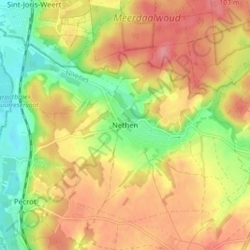
Name: Nethen topographic map, elevation, terrain.
Location: Nethen, Graven, Nijvel, Waals-Brabant, Wallonië, 3051, België (50.76382 4.65549 50.80382 4.69549)
Average elevation: 68 m
Minimum elevation: 21 m
Maximum elevation: 106 m
Thank you for supporting this site ❤️
Make a donation
Make a donation
Other topographic maps
Click on a map to view its topography, its elevation and its terrain.