
Make a donation
Flintstone topographic map
Click on the map to display elevation.
Make a donation
About this map
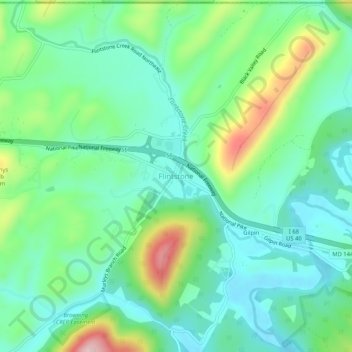
Name: Flintstone topographic map, elevation, terrain.
Location: Flintstone, Allegany County, Maryland, 21530, United States (39.68314 -78.58779 39.72314 -78.54779)
Average elevation: 294 m
Minimum elevation: 221 m
Maximum elevation: 481 m
Make a donation
Other topographic maps
Click on a map to view its topography, its elevation and its terrain.
Shaft
United States > Maryland > Allegany County > Borden Shaft > Braddock Estates
Shaft is a census-designated place (CDP) corresponding to the unincorporated community of Borden Shaft in Allegany County, Maryland, United States. As of the 2010 census, the CDP had a population of 235. It is located south of Frostburg, in the Georges Creek Valley. It lies at an elevation of 1,795 feet (547…
Average elevation: 588 m
Lavale Community Park
United States > Maryland > Allegany County > Allegany Grove
Average elevation: 354 m
Make a donation
Rawlings
United States > Maryland > Allegany County > Rawlings > Rawlings Heights
Average elevation: 262 m
Make a donation
County Fairgrounds
United States > Maryland > Allegany County > Potomac Park > Cedar Cliff
Average elevation: 274 m
Make a donation