
Thank you for supporting this site ❤️
Make a donation
Make a donation
Kaiama topographic map
Click on the map to display elevation.
Thank you for supporting this site ❤️
Make a donation
Make a donation
About this map
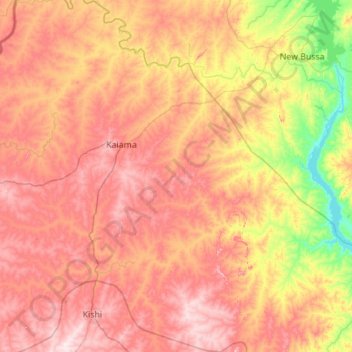
Name: Kaiama topographic map, elevation, terrain.
Location: Kaiama, Kwara State, Nigeria (8.96697 3.81025 10.05684 4.76456)
Average elevation: 280 m
Minimum elevation: 100 m
Maximum elevation: 471 m
Thank you for supporting this site ❤️
Make a donation
Make a donation
Other topographic maps
Click on a map to view its topography, its elevation and its terrain.
Thank you for supporting this site ❤️
Make a donation
Make a donation
Thank you for supporting this site ❤️
Make a donation
Make a donation