
Thank you for supporting this site ❤️
Make a donation
Make a donation
Namu topographic map
Click on the map to display elevation.
Thank you for supporting this site ❤️
Make a donation
Make a donation
About this map
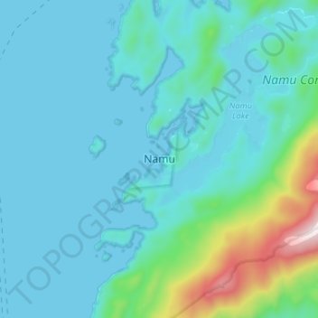
Name: Namu topographic map, elevation, terrain.
Average elevation: 126 m
Minimum elevation: -1 m
Maximum elevation: 948 m
Thank you for supporting this site ❤️
Make a donation
Make a donation
Other topographic maps
Click on a map to view its topography, its elevation and its terrain.
Edward Rock
Canada > British Columbia > Central Coast Regional District > Area A (Ocean Falls/Outer Coast)
Average elevation: 0 m
Area A (Ocean Falls/Outer Coast)
Canada > British Columbia > Central Coast Regional District > Area A (Ocean Falls/Outer Coast)
Average elevation: 586 m
Clyak Estuary Conservancy
Canada > British Columbia > Central Coast Regional District > Area A (Ocean Falls/Outer Coast)
Average elevation: 426 m