
Make a donation
Hyattsville topographic map
Click on the map to display elevation.
Make a donation
Hyattsville
Downtown Hyattsville underwent revitalization in the early 2000s with the development of Arts District Hyattsville, part of the Gateway Arts District, a private project which includes townhomes, live-work units, and retail space. The master developer of the 25-acre neighborhood was Bethesda-based EYA, and was constructed by EYA, PulteGroup, StreetSense, and Bozzuto Group. A Busboys and Poets restaurant opened in July 2011; other retail offerings include Yes! Organic Market, Elevation Burger, Chipotle Mexican Grill, Spice 6 Modern Indian, and Tara Thai. In the winter of 2015, a traveling exhibition platform Visual Collaborative collaborated with the Arts District Hyattsville Master Association, utilizing the Lustine Center to host a group exhibition themed Vanity.
Make a donation
About this map
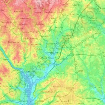
Name: Hyattsville topographic map, elevation, terrain.
Average elevation: 61 m
Minimum elevation: -3 m
Maximum elevation: 165 m
Make a donation
Other topographic maps
Click on a map to view its topography, its elevation and its terrain.
University Park
United States > Maryland > Prince George's County > University Park
University Park was developed on land owned by the Deakins family since the mid-1700s. The house known as Deakins Hall or Bloomfield was constructed on the land in the 1820s or 1830s. It is located at 6404 Queens Chapel Road. The farm was purchased by the University Park Company in 1923. The extension of water…
Average elevation: 29 m
Make a donation
Lake Artemesia
United States > Maryland > Prince George's County > College Park
Average elevation: 26 m
Make a donation
Rosaryville State Park
United States > Maryland > Prince George's County > Upper Marlboro
Average elevation: 59 m
Mount Rainier Community Food Forest
United States > Maryland > Prince George's County > Mount Rainier
Average elevation: 23 m
Make a donation
Make a donation