
Mt. Omaru topographic map
Interactive map
Click on the map to display elevation.
About this map
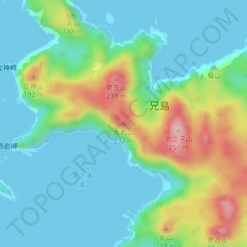
Name: Mt. Omaru topographic map, elevation, terrain.
Location: Mt. Omaru, Tokyo, 100-2101, Japan (27.12419 142.20150 27.12429 142.20160)
Average elevation: 65 m
Minimum elevation: -14 m
Maximum elevation: 242 m
Other topographic maps
Click on a map to view its topography, its elevation and its terrain.
Tokyo International Airport
Tokyo International Airport, Hanedakuko 2-chome, Tokyo, Japan
Average elevation: 2 m