
Thank you for supporting this site ❤️
Make a donation
Make a donation
Huntingtown topographic map
Click on the map to display elevation.
Thank you for supporting this site ❤️
Make a donation
Make a donation
About this map
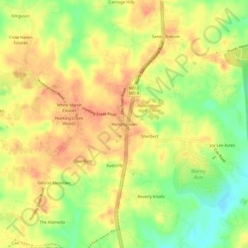
Name: Huntingtown topographic map, elevation, terrain.
Location: Huntingtown, Calvert County, Maryland, 21689, United States (38.59595 -76.63302 38.63595 -76.59302)
Average elevation: 36 m
Minimum elevation: 7 m
Maximum elevation: 55 m
Thank you for supporting this site ❤️
Make a donation
Make a donation
Other topographic maps
Click on a map to view its topography, its elevation and its terrain.