
Thank you for supporting this site ❤️
Make a donation
Make a donation
Cherry Valley topographic map
Click on the map to display elevation.
Thank you for supporting this site ❤️
Make a donation
Make a donation
About this map
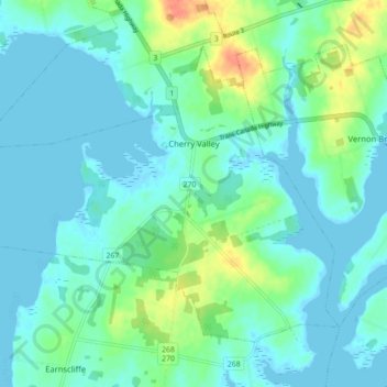
Name: Cherry Valley topographic map, elevation, terrain.
Location: Cherry Valley, Queens County, Prince Edward Island, Canada (46.14312 -62.97789 46.18991 -62.89016)
Average elevation: 10 m
Minimum elevation: -1 m
Maximum elevation: 44 m
Thank you for supporting this site ❤️
Make a donation
Make a donation
Other topographic maps
Click on a map to view its topography, its elevation and its terrain.