
Thank you for supporting this site ❤️
Make a donation
Make a donation
Daura topographic map
Click on the map to display elevation.
Thank you for supporting this site ❤️
Make a donation
Make a donation
About this map
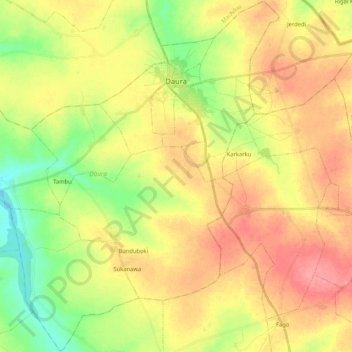
Name: Daura topographic map, elevation, terrain.
Location: Daura, Katsina State, Nigeria (12.87991 8.17210 13.08233 8.38061)
Average elevation: 480 m
Minimum elevation: 439 m
Maximum elevation: 518 m
Thank you for supporting this site ❤️
Make a donation
Make a donation
Other topographic maps
Click on a map to view its topography, its elevation and its terrain.