
Thank you for supporting this site ❤️
Make a donation
Make a donation
Khalsi tehsil topographic map
Click on the map to display elevation.
Thank you for supporting this site ❤️
Make a donation
Make a donation
About this map
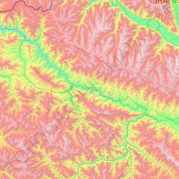
Name: Khalsi tehsil topographic map, elevation, terrain.
Location: Khalsi tehsil, Leh District, Ladakh, India (33.80433 76.41929 34.79610 77.25861)
Average elevation: 4,490 m
Minimum elevation: 2,831 m
Maximum elevation: 6,175 m
Thank you for supporting this site ❤️
Make a donation
Make a donation
Other topographic maps
Click on a map to view its topography, its elevation and its terrain.
Thank you for supporting this site ❤️
Make a donation
Make a donation
Thank you for supporting this site ❤️
Make a donation
Make a donation
Thank you for supporting this site ❤️
Make a donation
Make a donation