
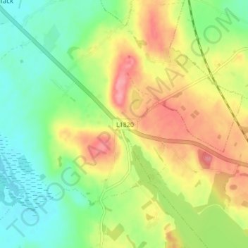
Bunbrosna topographic map
Click on the map to display elevation.
About this map
Name: Bunbrosna topographic map, elevation, terrain.
Average elevation: 97 m
Minimum elevation: 56 m
Maximum elevation: 149 m
Other topographic maps
Click on a map to view its topography, its elevation and its terrain.
Lough Lene
The lake is described in Samuel Lewis's Topographical Dictionary of Ireland (1837) as being an irregular oval shape, possibly 3.2 km (2.0 mi) long by 1.7 km (1.1 mi) broad. A fresh water lake, most sources focus on the clarity of the water, with the term "gin clear" being used to describe it. It sits…
Average elevation: 109 m