
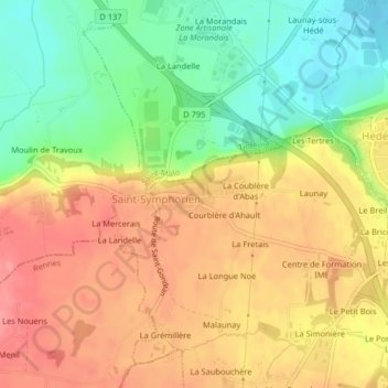
Saint-Symphorien topographic map
Interactive map
Click on the map to display elevation.
About this map
Name: Saint-Symphorien topographic map, elevation, terrain.
Average elevation: 86 m
Minimum elevation: 40 m
Maximum elevation: 124 m
Other topographic maps
Click on a map to view its topography, its elevation and its terrain.
Vitré
France > Brittany > Ille-et-Vilaine
The land area of Vitré: 37.19 km2 (14.36 sq mi). The average altitude of Vitré is approximately 89 m. The highest point, 127 m, is found in the "Ménardières" zone, at Pierre and Marie Curie Street. The lowest point, 67 m, is close to the firm S.V.A.'s location under the viaduct of the ring-road.
Average elevation: 94 m