
Boulogne-Billancourt topographic map
Interactive map
Click on the map to display elevation.
About this map
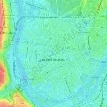
Name: Boulogne-Billancourt topographic map, elevation, terrain.
Average elevation: 43 m
Minimum elevation: 23 m
Maximum elevation: 113 m
Other topographic maps
Click on a map to view its topography, its elevation and its terrain.
Château Rothschild
Frankreich > Île-de-France > Boulogne-Billancourt
Château Rothschild, Allée de Longchamp, Boulogne-Billancourt, Hauts-de-Seine, Île-de-France, Metropolitanes Frankreich, 92100, Frankreich
Average elevation: 46 m