
Thank you for supporting this site ❤️
Make a donation
Make a donation
Mong Ton topographic map
Click on the map to display elevation.
Thank you for supporting this site ❤️
Make a donation
Make a donation
About this map
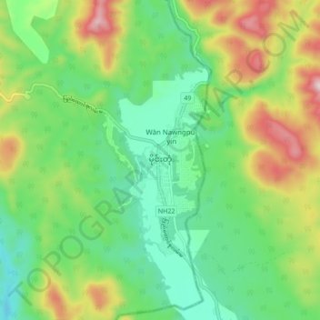
Name: Mong Ton topographic map, elevation, terrain.
Average elevation: 616 m
Minimum elevation: 411 m
Maximum elevation: 1,008 m
Thank you for supporting this site ❤️
Make a donation
Make a donation
Other topographic maps
Click on a map to view its topography, its elevation and its terrain.
Mong Hsat Township
Myanmar > Shan State > Mong Hsat District > Mong Hsat Township
Average elevation: 979 m
Thank you for supporting this site ❤️
Make a donation
Make a donation