
Thank you for supporting this site ❤️
Make a donation
Make a donation
Lightfoot topographic map
Click on the map to display elevation.
Thank you for supporting this site ❤️
Make a donation
Make a donation
About this map
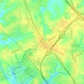
Name: Lightfoot topographic map, elevation, terrain.
Location: Lightfoot, James City County, Virginia, 23090, United States (37.32077 -76.77491 37.36077 -76.73491)
Average elevation: 30 m
Minimum elevation: 12 m
Maximum elevation: 44 m
Thank you for supporting this site ❤️
Make a donation
Make a donation
Other topographic maps
Click on a map to view its topography, its elevation and its terrain.
Jamestown Pointe Park
United States > Virginia > James City County > Pointe at Jamestown
Average elevation: 8 m