
Thank you for supporting this site ❤️
Make a donation
Make a donation
Ruisbroek topographic map
Click on the map to display elevation.
Thank you for supporting this site ❤️
Make a donation
Make a donation
Ruisbroek
Ruusbroek ligt op een hoogte van 22-25 meter aan de Zenne en het Kanaal Brussel-Charleroi. Door de nabijheid van de Brusselse agglomeratie is de plaats verstedelijkt en wordt ingesloten door infrastructuur (autoweg, HSL-lijn).
Thank you for supporting this site ❤️
Make a donation
Make a donation
About this map
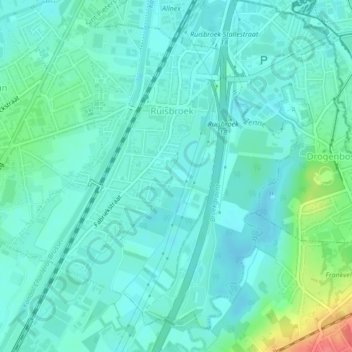
Name: Ruisbroek topographic map, elevation, terrain.
Average elevation: 29 m
Minimum elevation: 16 m
Maximum elevation: 79 m
Thank you for supporting this site ❤️
Make a donation
Make a donation
Other topographic maps
Click on a map to view its topography, its elevation and its terrain.
Sobroek
België > Vlaams-Brabant > Halle-Vilvoorde > Sint-Pieters-Leeuw > Vlezenbeek
Average elevation: 42 m