
Make a donation
Pittsburgh topographic map
Click on the map to display elevation.
Make a donation
Pittsburgh
Pittsburgh, located in Allegheny County, Pennsylvania, is characterized by its distinct and varied topography, shaped by the confluence of the Allegheny, Monongahela, and Ohio rivers. The city itself is situated at an average elevation of approximately 764 feet (233 meters) above sea level, with the terrain fluctuating between 686 feet (209 meters) and 1,391 feet (424 meters) at its highest points. The landscape features steep hills and valleys, which contribute to its scenic vistas and urban challenges, particularly in terms of transportation and infrastructure. Notably, neighborhoods like Mount Washington offer breathtaking panoramic views of the city skyline against the backdrop of rugged hills. The surrounding region exhibits a mix of forested areas and residential developments, reflecting the area's natural beauty and industrial heritage.
Make a donation
About this map
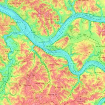
Name: Pittsburgh topographic map, elevation, terrain.
Location: Pittsburgh, Allegheny County, Pennsylvania, United States (40.36152 -80.09552 40.50120 -79.86573)
Average elevation: 303 m
Minimum elevation: 212 m
Maximum elevation: 413 m
Make a donation
Other topographic maps
Click on a map to view its topography, its elevation and its terrain.
Keown Station
United States > Pennsylvania > Allegheny County > Ross Township
Average elevation: 344 m
Make a donation
Champion
United States > Pennsylvania > Allegheny County > North Fayette Township
Average elevation: 360 m
Make a donation
Coraopolis Heights
United States > Pennsylvania > Allegheny County > Findlay Township
Average elevation: 320 m
Make a donation
Central Highlands
United States > Pennsylvania > Allegheny County > Elizabeth Township
Average elevation: 327 m
Sturgeon
United States > Pennsylvania > Allegheny County > North Fayette Township
Average elevation: 334 m
Make a donation
Observatory Hill
United States > Pennsylvania > Allegheny County > Pittsburgh
Average elevation: 319 m
Make a donation
Highland Park Reservoir No. 2
United States > Pennsylvania > Allegheny County > Pittsburgh
Average elevation: 275 m
Allegheny River Lock and Dam No. 2
United States > Pennsylvania > Allegheny County > O'Hara Township
Average elevation: 268 m
Make a donation
Stoneybrooke Woods
United States > Pennsylvania > Allegheny County > Cheswick
Average elevation: 283 m
Allison Park
United States > Pennsylvania > Allegheny County > Hampton Township
Average elevation: 324 m
Lovedale
United States > Pennsylvania > Allegheny County > Elizabeth Township
Average elevation: 298 m
Make a donation
Cochrans Mill
United States > Pennsylvania > Allegheny County > Jefferson Hills
Average elevation: 311 m
Make a donation
Neville Island
United States > Pennsylvania > Allegheny County > Neville Township
Average elevation: 289 m
Coverdale
United States > Pennsylvania > Allegheny County > Bethel Park > Coverdale
Average elevation: 354 m
Carnot
United States > Pennsylvania > Allegheny County > Moon Township > Carnot
Average elevation: 336 m
Make a donation
Clinton
United States > Pennsylvania > Allegheny County > Findlay Township > Clinton
Average elevation: 350 m
Glenwillard
United States > Pennsylvania > Allegheny County > Crescent Township > Glenwillard
Average elevation: 278 m
Dorseyville
United States > Pennsylvania > Allegheny County > Indiana Township
Average elevation: 325 m
Make a donation