
Thank you for supporting this site ❤️
Make a donation
Make a donation
Davis topographic map
Click on the map to display elevation.
Thank you for supporting this site ❤️
Make a donation
Make a donation
Davis
Davis lies in the Sacramento Valley, the northern portion of the Central Valley, in Northern California, at an elevation of about 52 feet (16 m) above sea level.
Thank you for supporting this site ❤️
Make a donation
Make a donation
About this map
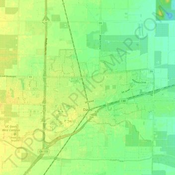
Name: Davis topographic map, elevation, terrain.
Location: Davis, Yolo County, California, United States (38.53491 -121.79398 38.57555 -121.67567)
Average elevation: 14 m
Minimum elevation: 4 m
Maximum elevation: 23 m
Thank you for supporting this site ❤️
Make a donation
Make a donation
Other topographic maps
Click on a map to view its topography, its elevation and its terrain.
Thank you for supporting this site ❤️
Make a donation
Make a donation
Davis
United States > California > Yolo County > Davis > Davis
Davis lies in the Sacramento Valley, the northern portion of the Central Valley, in Northern California, at an elevation of about 52 feet (16 m) above sea level.
Average elevation: 15 m
Thank you for supporting this site ❤️
Make a donation
Make a donation